By Frances Lam
Consequences of Ineffective Fire Management | Own Operation | How Musim Mas Minimises False Fire “Hotspot” Alerts for Suppliers | Standard and Regulation | Peat Management
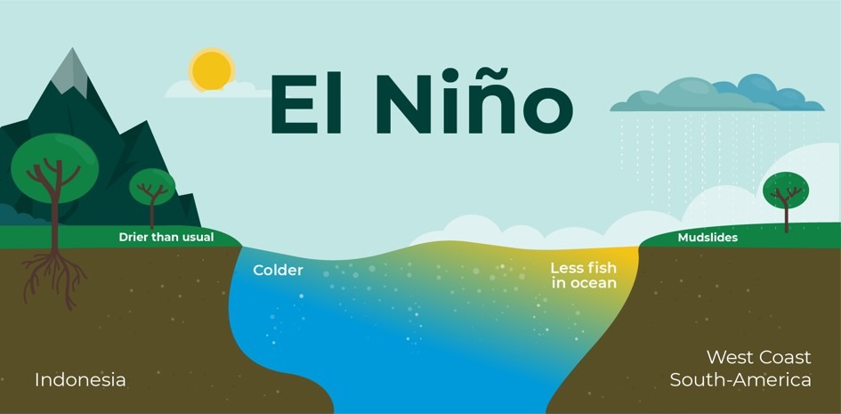
El Niño is a climate phenomenon characterized by warmer-than-normal sea surface temperatures in the central and eastern Pacific, which weakens trade winds and disrupts global weather patterns. The term “El Niño” comes from Spanish, where it literally means “little boy.” When capitalized, however, it refers specifically to the “Christ child,” reflecting the phenomenon’s link to the Christmas season. The name was first used by South American fishermen in the 1600s, who observed an unusual warming of the Pacific Ocean’s surface every few years around December. The fishermen then named the phenomenon “El Niño de Navidad”, which was later shortened to “El Niño”.
In Southeast Asia, El Niño often brings drier weather, prolonged droughts, rising temperatures, and a higher likelihood of wildfires and smoke haze. Approximately 135,000 ha of forest in Indonesia were degraded by fires in 2019 Prasetyo, et al., 2022, caused by prolonged drought associated with the El Nino ˜ phenomenon, which also triggered major forest fires in 2015 (Field et al., 2016; NASA, 2016)
Environmental factors, meteorological conditions, topography, and the presence of fuel sources, such as small branches, dry leaves, shrubs, grasses, and peatlands, especially during the hot, dry season, are natural causes of forest fires (Lestari et al., 2022)
Anthropogenic factors involve human activities, such as agricultural expansion, mining, oil palm plantations, and road density (Lestari et al., 2022; Nelson et al., 2021; Horton et al., 2021).
During El Niño years, these natural and human-driven factors interact with more extreme drought and heat, significantly amplifying fire risk. We continue to implement our fire prevention and management measures in line with established procedures, and we are strengthening preparedness and vigilance.
Consequences of Ineffective Fire Management
During El Niño years, these natural and human-driven risk factors are intensified by more extreme drought and heat. In this context, Indonesia is expected to experience a drier, earlier, and more intense dry season than usual. According to the Meteorology, Climatology and Geophysics Agency (BMKG). By the end of June, nearly 66% of the country is projected to be in the dry season.
Without strong prevention, monitoring, and response measures, wildfires can escalate quickly and burn out of control. Below is a summary of the potential environmental, social, and governance impacts that can result from :
Environmental impacts:
- Rapid, uncontrolled fires destroy forests, wetlands, and other critical ecosystems.
- Loss of vegetation accelerates soil erosion and reduces water quality.
- Air pollution from smoke increases greenhouse gas emissions, worsening climate change.
- Habitat destruction threatens biodiversity and disrupts natural ecological balance.
- Repeated intense fires can lead to land degradation and desertification
Social Impacts:
- Homes, farms, and infrastructure are at risk of destruction, leading to displacement.
- Communities face increased health risks from poor air quality, including respiratory illnesses.
- Reduced agricultural productivity impacts food security and livelihoods.
- Psychological stress and trauma rise among affected populations.
- Cultural heritage sites and traditional lands may be permanently damaged or lost.
Governance:
- Emergency response systems become overwhelmed, exposing weaknesses in disaster preparedness.
- High recovery and reconstruction costs strain government budgets.
- Poor coordination among agencies delays effective firefighting and relief efforts.
- Economic losses can undermine development plans and national resilience.
- Loss of public trust in authorities can grow if responses are perceived as slow or inadequate.
Own operations
In Musim Mas, a strong focus is placed on preventing fires to protect local communities and ecosystems, while also reducing haze and greenhouse gas emissions in the region. To support this objective, clear policies, standard operating procedures, and designated roles have been put in place for the management of fire risk across our operations.
Zero Burning Policy
Zero Burning Policy is applied across all Musim Mas’ own operations. Under this policy, fire is not permitted for land clearing, replanting, or any other agricultural activities. Our zero-burning policy is also accompanied by policies that reduce the risk of fires, such as our NDPE (No Deforestation, No Peat, No Exploitation) policy.
The policy is designed to prevent transboundary haze, lower carbon emissions from land clearing and peatland fires, and strengthen the protection of biodiversity and surrounding landscapes. All estate managers and contractors are required to adhere to this policy, and any non‑compliance is treated as a serious breach of our environmental and social commitments.
Fire Danger Rating system
The Fire Danger Rating (FDR) system assesses wildfire risk within and around the Group’s concessions, guiding prevention, monitoring, response, and resource allocation.
Risk levels range from low to extreme, based on meteorological and operational indicators, including:
- Daily rainfall and other weather conditions that influence fuel and peat moisture.
- Detected hotspots within the concession and in its immediate surroundings.
- Observed wildfire indications from surrounding areas, including land-use activities and smoke.
For each FDR category, a corresponding set of operational controls is established. At higher FDR categories, monitoring and preparedness measures are strengthened, including more frequent patrols and fire watchtower surveillance.
- In high danger conditions, the Group may block water channels and peatland canals to maintain water levels and reduce peat fire risk.
- At extreme danger levels, the Group activates enhanced response protocols, including active fire suppression and coordination with the Regional Disaster Management Agency and the Forest Fire Brigade (Manggala Agni).
Prevention and Management
For plantations on peat within our own operations, we apply peatland management practices in accordance with applicable regulations, as well as the national and sustainability standards, e.g. the ISPO and RSPO. This includes installing and maintaining water‑control structures to regulate water levels and keep water tables within recommended ranges, to lower fire risk and associated GHG emissions.
Fire prevention infrastructure in our plantations includes:
- Install, maintain and improve firebreaks, water sources, firefighting equipment and access routes to reduce the likelihood and spread of fires.
- Conduct regular inspections of high-risk areas, including peatlands and estate boundaries adjacent to third-party land, to identify and address fire and drought-related risks.
- Ensuring that water sources for firefighting, such as ponds and reservoirs, are maintained separately from boreholes constructed to provide clean water for workers living on our operations.
Our fire prevention and management measures also include the daily monitoring of our concessions and surrounding areas within a 3‑kilometre radius, using publicly available satellite data from the NASA FIRMS platform. When a hotspot is detected in or near an estate, its coordinates are reviewed and confirmed by the head office team, after which the satellite information and hotspot maps are provided to the relevant site team.
Ground‑truthing and field verification are then carried out by the location team, and the findings are reported back to head office so that any further response measures considered necessary can be coordinated.
More information is available in our Fire Prevention Report.
How Musim Mas Minimises False Fire “Hotspot” Alerts for Suppliers
Hotspots are often misunderstood as signs of active fires. A hotspot is defined instead as a satellite-detected heat anomaly, rather than a confirmed fire. Such anomalies may be caused by agricultural activity, industrial operations, or natural land features. Accordingly, hotspots are treated as indicators that require further checking, not as definitive proof of fire.
Challenges include:
- Limitation in Satellite data accuracy
- Supplier engagement and ground-truthing
- Balancing false alerts and missed fires
To avoid unnecessary alarms and the communication of inaccurate information, a structured procedure for handling hotspot alerts is followed. Only medium- and high-confidence hotspots are reviewed, and extra attention is given to clusters within supplier concessions or within 5 km of mills. Suppliers are asked to clarify any relevant alerts within five working days, so potential risks are still picked up quickly while unnecessary alarms and misleading information are kept in check.
What are the technological advantages of Musim Mas for hotspot monitoring?
Daily hotspot monitoring is carried out using multiple satellite-based systems, including VIIRS (J1 VIIRS, J2 VIIRS, and Suomi NPP VIIRS) and MODIS. Potential fire activity is identified through the regular scanning of these satellites.
When more than one hotspot is detected in a supplier’s area, a notification is sent to the respective supplier on the same day, together with key information such as the coordinates, date of detection, and the satellite used (MODIS or VIIRS). If the hotspots continue to appear on consecutive days, clarification is requested from the suppliers.
Suppliers are asked to confirm whether the hotspot represents an actual fire, supported by geo-tagged photos and details of any mitigation or containment actions taken, if applicable.
- When a satellite pixel is significantly hotter than its surrounding area, it is flagged as a hotspot.
- This method can detect a wide range of fire activity, including wildfires, agricultural burning, and peat or forest fires.
- Non-fire heat sources, such as industrial activity, are filtered out during data processing to reduce false alarms.
- MODIS provides a long-term, consistent record that is useful for analysing trends over time.
- Higher-resolution VIIRS sensors can detect smaller and cooler fires and offer more frequent observations, strengthening day-to-day monitoring.
- Together, these systems support the calculation of Fire Radiative Power (FRP), which helps estimate the intensity of a fire and its emissions.
By combining these satellite systems, fire spread, duration, and intensity can be monitored more reliably, allowing hotspots near concession areas to be identified early so that teams can mobilise quickly, contain fires before issues escalate, and minimise environmental damage.
Drones in action
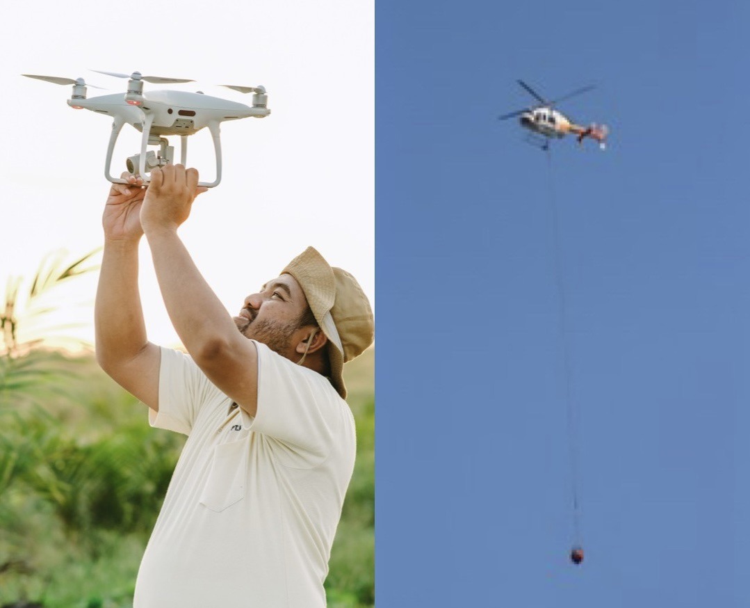
When a hotspot is detected, the GPS coordinates are sent to the Estate Department, which alerts the Plantation GIS and/or General Affairs team. The GIS team is then deployed to the site to verify the situation on the ground. Drones give the team an extra edge, allowing effective observation of remote areas without needing to be physically present. In provinces that are highly prone to fires, aerial firefighting methods are employed in addition to standard firefighting equipment and infrastructure.
Supplier Plantation Improvements and Engagement
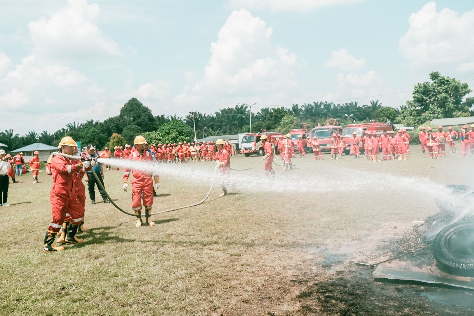
Engaging suppliers is a key component of our operations, as almost 90% of our palm oil supply comes from third-party partners. Through the Supplier Assessment Tool (SAT), fire risks within suppliers’ concessions are assessed, and the no-burning policy is reinforced through dedicated workshops. SAT responses enable us to pinpoint areas for improvement and create tailored, time-bound action plans to support suppliers in meeting our policy commitments.
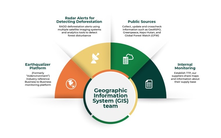
Since the launch of Musim Mas’ sustainability policy in 2014, deforestation and fire hotspots have been tracked in an in-house database. The GIS monitoring system was used to identify high-risk areas, where suppliers are engaged through targeted programs to address and prevent fires.
Musim Mas currently conducts monitoring only within its concession areas and within a 5 km radius of suppliers that do not hold concessions.
Total monitored in 2025
Building on our daily hotspot monitoring system described in Section 3.3.1, in FY2025 Musim Mas applied this approach across all supplier concession areas and surrounding landscapes .
In FY2025, hotspot monitoring covered a total of 3,364,502 hectares of supplier concession areas across 394 mills. A 5 km radius buffer was applied to suppliers without concessions, covering 1,294,709 hectares across 175 mills. In total, 4,659,211 hectares across 569 mills were monitored. Suppliers are required to verify the ground conditions and take necessary action within five working days. This clear and firm timeline ensures accountability and compliance with our Zero Burning Policy, helping maintain a responsible, fire-free supply chain.
Case Study
In 2025 during the hot season from June to July, we identified high confidence level of hotspots in our suppliers’ concession and/or supply shed and we sent the hotspot notifications to suppliers for them to take immediate actions.
From the notifications that we sent to suppliers, we were informed that around 70% of the hotspots were fire incidents that occurred within their concession areas, originating from land clearing activities by local communities outside the concession, with the fires spreading into the concession areas. The remaining hotspots are confirmed to have occurred within a 5 km radius from their mill, caused by the drought season.
In the clarification, suppliers stated that they actively conduct regular monitoring and respond promptly to any fire incidents within their areas.
Suppliers that provided clarification generally demonstrated proactive preventive measures, including:
- Routine ground patrols to detect early fire risks
- Community outreach and awareness programs discouraging land clearing through burning
- Stronger collaboration between companies, suppliers, and local stakeholders
Standards and Regulations
Musim Mas adheres to a strict zero-burning policy embedded within its Sustainability Policy, which forms the foundation of its No Deforestation, No Peat, and No Exploitation (NDPE) commitments. These standards are communicated and enforced across all third-party suppliers.
Sustainability standards such as ISPO, MSPO, and RSPO require certified mills to implement fire prevention and management systems. For RSPO-certified suppliers, this includes compliance with the No Burning Policy. In 2025, Musim Mas had 252 ISPO-certified, 111 MSPO-certified, and 169 RSPO-certified suppliers, reflecting strong alignment with these requirements.
Government Regulation
At the national level, Indonesian regulations prohibit land clearing through burning, as stipulated in Article 69(1)(h) of Law No. 32/2009 on Environmental Protection and Management, which states that any person is prohibited from clearing land by burning. However, Article 69(2) provides that this provision shall consider local wisdom in respective regions.
This has led to the development of regional regulations that allow controlled burning under specific conditions. For example, in West Kalimantan, Governor Regulation No. 103/2020 on land clearing for agricultural purposes based on local wisdom states under Article 6 that each farmer is permitted to clear land through limited and controlled burning of up to 2 hectares per household, in accordance with local practices.
Community and Independent Smallholders
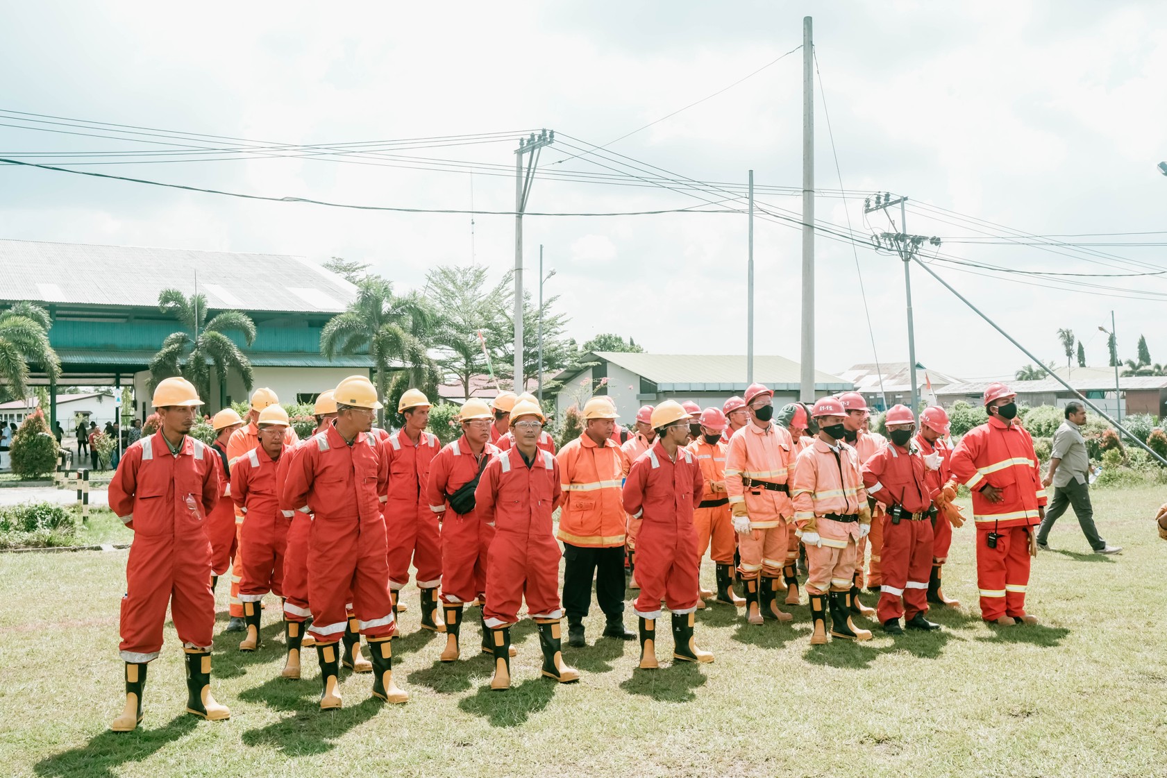
Independent smallholders are also a crucial part of the solution, representing 41% of Indonesia’s oil palm plantations. Musim Mas runs the country’s largest smallholder training program, integrating “zero burning” methods, fire prevention training and sustainable farming practices to reduce fire risks. By encouraging alternatives to slash-and-burn agriculture, these programs help create long-term, fire-resilient landscapes.
The group also assists farmers in accessing funding from the Oil Palm Plantation Fund Management Agency (BPDPKS) to implement oil palm rejuvenation programs without burning land.
In the smallholder program, the use of organic litter as compost is encouraged to minimize soil and nutrient erosion, rather than relying on burning. Smallholders are also made aware of relevant government regulations regarding burning practices.
During farmer group training sessions, the risks and dangers associated with fire are highlighted. The program further promotes alternative livelihood opportunities—such as cattle rearing or cultivating other crops, to provide more sustainable income sources for smallholders.
In addition to remote hotspot monitoring, Musim Mas also works directly with communities to prevent fires on the ground through the Fire-Free Village Programme. As we wrap up the Fire-Free Village Programme, Musim Mas in 2025 supported 76 villages across 492,325 hectares, delivered 133 training sessions, and recognised 36 villages for successfully remaining fire-free.
Peat Management
The company prevents haze from peat fires by managing water tables through a network of canals and control structures, keeping peatlands moist and more resistant to fire.
- Water management: Maintains peat hydrology through canals, water gates, and canal-blocking systems to keep peatlands moist and fire-resistant.
- Conservation commitment: Protects over 4,000 hectares of peat as conservation areas, with no new development permitted.
- Best practices: Regulates groundwater levels (e.g. around 40–80 cm below the surface) to prevent drying and reduce fire risk.
- Monitoring: Regularly tracks water tables and land subsidence using field measurement tools.
- Compliance: Aligns with Indonesian regulations and sustainability standards such as RSPO and POIG to minimise fire risk and emissions
Musim Mas’ experience demonstrates that effective fire prevention is achieved by staying one step ahead rather than reacting only when smoke is visible. By combining climate awareness, daily satellite-based hotspot monitoring, drone verification, and clearly defined SOPs for suppliers, potential risks are identified early and can be addressed before small incidents escalate into large fires and haze.
At the same time, these efforts are supported by wider measures, including supplier and smallholder training, enforcement of a zero-burning policy, peatland protection, and alignment with national regulations and international sustainability standards. In this way, more fire-resilient landscapes are fostered, contributing to cleaner air, healthier communities, and a more responsible palm oil supply chain that delivers benefits well beyond plantation boundaries.
Reference:
Prasetyo, L.B. et al., 2022. Assessing sumatran peat vulnerability to fire under various condition of ENSO phases using machine learning approaches. Forests 13(6), doi: 10.3390/f13060828.
Hidayanto, N., Saputro, A.H., Nuryanto, D.E., 2021. Peatland data fusion for forest fire susceptibility prediction using machine learning. In: 2021 4th International Seminar on Research of Information Technology and Intelligent Systems, ISRITI 2021, pp. 544–549, 2021, doi: 10.1109/ISRITI54043.2021.9702762.
Seddouki, M., Benayad, M., Aamir, Z., Tahiri, M., Maanan, M., Rhinane, H., 2023. Using machine learning coupled with remote sensing for forest fire susceptibility mapping. Case Study Tetouan Province, Northern Morocco. International Archives of the Photogrammetry, Remote Sensing and Spatial Information Sciences – ISPRS Archives, vol. 48, no. 4/W6-2022, pp. 333–342, 2023, doi: 10.5194/isprs-archivesXLVIII-4-W6-2022-333-2023.
Burapapol, K., Nagasawa, R., 2016. Mapping soil moisture as an indicator of wildfire risk using Landsat 8 images in Sri Lanna National Park, Northern Thailand. J. Agric. Sci. 8 (10), 107. https://doi.org/10.5539/jas.v8n10p107.
Naderpour, M., Rizeei, H.M., Ramezani, F., 2021. Forest fire risk prediction: a spatial deep neural network-based framework. Remote Sens (Basel) 13(13), doi: 10.3390/ rs13132513.
Tan, C., Feng, Z., 2023. Mapping forest fire risk zones using machine learning algorithms in Hunan Province, China. Sustain. (Switzerland), vol. 15, no. 7, 2023, doi: 10.3390/ su15076292.